You plan to move to the Philippines? Wollen Sie auf den Philippinen leben?

There are REALLY TONS of websites telling us how, why, maybe why not and when you'll be able to move to the Philippines. I only love to tell and explain some things "between the lines". Enjoy reading, be informed, have fun and be entertained too!

Ja, es gibt tonnenweise Webseiten, die Ihnen sagen wie, warum, vielleicht warum nicht und wann Sie am besten auf die Philippinen auswandern könnten. Ich möchte Ihnen in Zukunft "zwischen den Zeilen" einige zusätzlichen Dinge berichten und erzählen. Viel Spass beim Lesen und Gute Unterhaltung!


Visitors of germanexpatinthephilippines/Besucher dieser Webseite.Ich liebe meine Flaggensammlung!

free counters

Google

Showing posts with label PAGASA. Show all posts

Saturday, August 21, 2021

Isang' intensifies into tropical storm — PAGASA


by Ellalyn De Vera-Ruiz, Manila Bulletin

Tropical cyclone “Isang” (international name “Omais”) has intensified into a tropical storm while over the Philippine Sea on Friday evening, Aug. 20, the Philippine Atmospheric, Geophysical and Astronomical Services Administration (PAGASA) said in its 11 p.m. bulletin.

PAGASA said that storm Isang has maximum sustained winds of 65 kilometers per hour (kph) near the center and gustiness of up to 80 kph.

Its location was estimated 835 kilometers east of extreme northern Luzon as of 10 p.m.

PAGASA said the storm is still not expected to have a direct effect on the country until it leaves the Philippine area of responsibility on Sunday, Aug. 22.

Isang may continue to intensify until Saturday evening, Aug. 21 when it is likely to reach its peak intensity.

“A weakening trend may commence by Sunday which may result in Isang being downgraded to tropical depression category by Monday evening (Aug. 23),” PAGASA said.

The State weather bureau pointed out that the easterlies or the warm winds coming from the Pacific Ocean remain the dominant weather system that may bring partly cloudy to cloudy conditions across the country in the next 24 hours.

However, there is a high chance of isolated rain showers or thunderstorms, particularly in the afternoon or evening.

PAGASA warned the public against flash floods or landslides that may occur during severe thunderstorms, which are often associated with short-lived heavy rain, lightning, thunder, gusty winds, and sometimes hail.

Saturday, January 9, 2021

PAG-ASA GONE AT 28 💔


By Ian Garcia, Davao City

The Philippine Eagle Foundation is sad to announce the passing of beloved Philippine Eagle, Pag-asa.  Pag- asa succumbed to infections associated with Trichomoniasis and Aspergillosis. Both diseases are fatal for raptors. Although treatment was done over a week ago, he continued to deteriorate and died at 8:03 pm on January 6. 

Pag-asa would have turned 29 years old on Jan 15, 2021.  He was the first-ever Philippine Eagle bred and hatched in captivity using the cooperative artificial insemination techniques. Pag-asa’s birth- the culmination of 14 years worth of research, heralded hope for the critically endangered species and the entire conservation mission.

Years after he was hatched, the PEF reached yet another milestone with Pag-asa in the form of his first and only offspring. She was named Mabuhay and was also bred and hatched through CAI. Even after he retired from breeding, Pag-asa lived his life as an icon of hope for Filipinos, young and old, and was a constant inspiration to the people working tirelessly to save our National Bird from extinction.

Pag-asa was gone too soon indeed, but his legacy lives on. (PEF PR)

Friday, November 25, 2016

Marce to hit Cebu today

 0  0 googleplus0  0 
It was not fog that hung over the skies of Cebu yesterday, but thick clouds brought on by tropical depression Marce, according to the state weather bureau. Storm signal number 1 was raised over Cebu City yesterday leaving hundreds of passengers stranded in the different seaports. Aldo Nelbert Banaynal
CEBU, Philippines - After causing thousands to be stranded yesterday, tropical depression Marce is expected to make landfall in Cebu early this morning.
PAGASA-Visayas weather specialist Bolivar Artiaga said Marce will continue to bring more rains and people in landslide-prone areas should be watchful.
"Magbantay g’yud ta labi na kadtong mga landslide-prone areas kay posible mag landslide tungod aning sige og uwan-uwan," said Artiaga.
He also said that yesterday almost the entire Cebu sky was engulfed by thick clouds that lowered visibility, it was not fog as many thought.
Close Ad X

"Di to siya fog. Tungod lang gyud to sa uwan nga niubos ang visibility. Unya dag-um sad kaayo ang Cebu," Artiaga said.
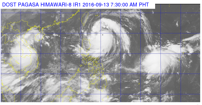
Based on the PAGASA weather bulletin as of 8 p.m. last night, Marce made landfall in Siargao Island, Surigao del Norte. The estimated rainfall amount is from moderate to heavy within the 300 kilometers of the tropical depression.
Freeman ( Article MRec ), pagematch: 1, sectionmatch:
Signal no. 1 is still in effect in Biliran, Southern Samar, Eastern Samar, Leyte, Southern Leyte, Bohol, Cebu including Bantayan and Camotes Islands, Siquijor, Negros Oriental, Negros Occidental, Iloilo, Capiz, Aklan, Antique and Guimaras in the Visayas.
Marce is expected to be out of the country by Monday afternoon.
A total of 52 vessels, 17 motorbancas and 81 cargo vessels were not allowed to travel from Cebu to other provinces due to unfavorable weather brought about by tropical depression Marce yesterday.
Paul Alcances, duty officer of the Philippine Coast Guard Cebu Station said that as of 8 p.m. last night, 2,522 passengers were stranded after vessels plying Leyte,  Bohol, Camotes,  Cagayan de Oro, Masbate, Sta. Fe in Bantayan Island,  San Carlos  City, Escalante in Negros Oriental and Dipolog routes were barred from travelling.
In the Mactan-Cebu International Airport, four flights plying the Cebu-Surigao/Surigao-Cebu routes were cancelled due to the bad weather, said MCIA corporate communication junior manager Malou Mozo.

Education is priority

Despite the tropical depression, some schools in the city will have classes today as Mayor Tomas Osmeña did not order to suspend the classes.
Saying education is his priority, Osmeña said he does not see the need to hit the panic button.
“There’s classes. The only exception would be in certain schools which are exposed to slides, the children cannot go home, or if they will have to cross the river like Barangay Buot,” he said, adding schools in barangays Busay and Sapangdaku should also suspend classes.
However, he clarified that school principals have the discretion to suspend the classes depending on the situation of the schools today.
“I have the responsibility of not hitting the panic button. If there’s a real danger, there’s always a danger, but if you talk about lesser danger, you don’t need to give many instructions because people will get confused,” he said.
Cebu City Disaster Risk Reduction and Management Council head Nagiel Bañacia said the suspension of classes shall be treated on a case-to-case basis depending on the situation.
With this, Bañacia encouraged the public to be alert, saying there are 19 upland barangays prone to landslides while five urban barangays are prone to flooding.
The mountain barangays that are highly susceptible of landslides are Lusaran, Binaliw, Guba, Budlaan, Malubog, Buot, Busay, Sirao, Taptap, Adlaon, Tagba-o, Tabunan, Pung-ol Sibugay, Sudlon 1, Sudlon 2, Sinsin, Buhisan, Pamutan, and Sapangdaku.
The urban barangays that are highly susceptible to flood are Bonbon, Labangon, Kasambagan, Kinasang-an, and Mabolo.
He said responders are on standby to respond to any eventualities while contractor’s association has committed to deploy their heavy equipment in case of landslides in the upland barangays.
For emergencies, he said the public may call numbers: 032-2621424 and 0923-5248222.
Mandaue City Mayor Gabriel Luigi Quisumbing yesterday declared suspension of classes in all public elementary schools due to the bad weather.
"In light of the impending landfall of TS Marce in Surigao this afternoon which is expected to bring heavy rains to Cebu, afternoon classes in Elementary Public Schools in Mandaue City are hereby cancelled," Quisumbing said.
In Talisay, the city also declared class suspension yesterday and today for all levels.
The tropical depression may bring heavy rains and the city government said this might affect Barangay Manipis which is prone to landslide, and other barangays that are prone to flooding.

Code red

The Provincial Disaster Risk Reduction and Management Office placed the whole province of Cebu under Code Red: Charlie.
“Base sa protocol, naa man gitawag sa alpha, bravo, charlie. Charlie naa ta, Code Red: Alert Charlie. Naa ta sa gitawag nga minimum critical preparation,” PDRRMO head Baltazar Tribunalo said.
With the storm signal, the Cebu provincial government suspended classes in all levels in public schools throughout the province yesterday and today.
Private schools, on the other hand, were advised to dismiss classes, especially in areas prone to flashfloods and/or landslides.
The Cebu provincial government fielded all heavy equipment units in the northern and southern parts of Cebu for immediate response in case of landslides. The PDRRMO also warned coastal residents of possible storm surges.

Church refuge

Meanwhile, Cebu Archbishop Jose Palma yesterday asked churches and chapels throughout the province to accommodate any evacuees who may be displaced or seeking safety from landslides or floods. — Mitchelle L. Palaubsanon, Kristine B. Quintas, Le Phyllis F. Antojado, Jean Marvette A. Demecillo, Garry B. Lao, Iris Mariani B. Algabre (FREEMAN)

Tuesday, September 13, 2016

Batanes under Signal No. 4 as 'Ferdie" Intensifies

By: Frances Mangosing, Philippine Daily Inquirer
This satellite image from Pagasa shows the location of Typhoon Ferdie as of 7:30 a.m. Tuesday.
Batanes was placed under Signal No. 3 as Typhoon “Ferdie” (international name: Meranti) intensified and posed a threat over extreme northern Luzon on Tuesday.
The typhoon packed maximum sustained winds of 215 kilometers per hour (kph) near the center, up from 195 kph and gusts of up to 250 kph, up from 230 kph, the Philippine Atmospheric, Geophysical and Astronomical Services Administration (Pagasa) said.
Signal No. 2 was raised in Northern Cagayan and Babuyan Group of Islands, while Signal No. 1 was raised over the rest of Cagayan, northern Isabela, Kalinga, Apayao, Abra and Ilocos Norte.
Ferdie was last tracked 510 kilometers east of Calayan in Cagayan and was moving west northwest at 22 kph.
“Residents in Northern Luzon are advised to take precautionary measures against impacts of very strong winds and heavy rainfall,” Pagasa said.
By Wednesday, Ferdie is forecast over the vicinity of Basco, Batanes and by Thursday morning, it will be 345 kilometers west northwest of Itbayat in Batanes, or outside the Philippine area of responsibility.
Moderate to heavy rains are expected within the 500 kilometer-diameter of the typhoon.
Cloudy skies with light to moderate rains and isolated thunderstorms are expected over Northern Mindanao, Visayas and the rest of Luzon, Pagasa said.
Partly cloudy to cloudy skies with isolated rainshowers or thunderstorms will prevail over the rest of Mindanao.
In its 7:30 a.m. update, Pagasa said a thunderstorm is affected Bataan, Zambales, Cavite and Batangas. Laguna and Quezon may experience the same in the next two hours, while Metro Manila may get light to moderate showers. IDL

Friday, November 20, 2015

Tropical Storm expected again to enter Philippines

 (The Philippine Star) | 

 1  346 googleplus1  0 
Shelly Ignacio, weather forecaster of the Philippine Atmospheric, Astronomical Services Administration (PAGASA), said yesterday the storm with international name Infa is likely to intensify into a typhoon before it enters the Philippine area of responsibility by Sunday or Monday. from pagasa.dost.gov.ph
MANILA, Philippines - A tropical storm spotted over the Pacific Ocean is expected to enter the Philippine area of responsibility this weekend or early next week and bring rains over the eastern section of Luzon and the Visayas.
Shelly Ignacio, weather forecaster of the Philippine Atmospheric, Astronomical Services Administration (PAGASA), said yesterday the storm with international name Infa is likely to intensify into a typhoon before it enters the Philippine area of responsibility by Sunday or Monday.
The storm will be locally named Marilyn once it enters the Philippine area of responsibility.
Ignacio said the storm was not expected to make landfall in any part of the country.
PAGASA was looking at two scenarios for Infa, one where it enters the Philippine area of responsibility on Sunday or Monday and grazes the eastern section of Luzon, particularly the Bicol region and the Visayas, while the other scenario is the storm would veer north and spare the country, Ignacio said.
As of yesterday noon, the storm was moving west northwest at a speed of 20 kilometers per hour.
Headlines ( Article MRec ), pagematch: 1, sectionmatch: 1
“The possibility that it will enter the Philippine area of responsibility is high,” Ignacio told The STAR.
As of 2 a.m. Thursday, the eye of Infa was located at 2,980 km east of Mindanao.
She said partly cloudy skies with chances of isolated thunderstorms would prevail over Metro Manila in the next three days.

Monday, October 6, 2014

The Next Typhoon is On the Way ...


 A new typhoon hovering over the Pacific Ocean was forecast to enter the Philippine area of responsibility on Wednesday but the state weather bureau said it is unlikely to affect any part of the country as it moves toward Japan.
Vongfong was expected to pass through the northeastern boundary of the country on Wednesday or Thursday, the Philippine Atmospheric, Geophysical and Astronomical Services Administration (PAGASA) said yesterday.
Vongfong will be locally named Ompong once it enters the Philippine
area of responsibility, PAGASA said.
It said Vongfong may follow the track of Typhoon Neneng (Phanfone), which exited the country on Saturday.
“If it maintains its current track of west-northwest, it may enter the Philippine area of responsibility by Wednesday or Thursday,” PAGASA weather forecaster Fernando Cada said.
The weather bureau said that light to moderate rains may affect the eastern section of Luzon, Palawan and the Visayas on Wednesday due to the trough of the typhoon.
Headlines ( Article MRec ), pagematch: 1, sectionmatch: 1
The rest of the country will have partly cloudy to cloudy skies apart from rainshowers or thunderstorms, it added.
PAGASA said the tropical cyclone was forecast to move toward the southern islands of Japan.
“It is not expected to make landfall in any part of the country,” the weather bureau said.
Meanwhile, PAGASA said the intertropical convergence zone will continue to bring cloudy skies with light to moderate rainshowers and thunderstorms over the Visayas, Bicol region, Caraga and the provinces of Mindoro until today.
Metro Manila and the rest of the country will be partly cloudy to cloudy with isolated rainshowers or thunderstorms.
PAGASA said the coastal waters of Northern Luzon will be moderate to rough in the next 24 hours.
 
(C) 2014 by Philippine Star

Thursday, January 2, 2014

HAPPY NEW YEAR! FROHES NEUES JAHR 2014!

"Shooting stars" from the brilliant Quadrantid meteor are kicking off a new year of skywatching for Filipinos.

According to the Philippine Atmospheric, Geophysical, and Astronomical Services Administration (PAGASA) Acting Administrator Dr. Vicente Malano, the annual Quadrantid meteor show will be active from Jan.1 to Jan. 7.


He said the observation of its peak activity is Jan. 3-4 in which meteors or "falling stars" can be seen at the rate of at least 40 meteros per hour. The meteor shower will appear to radidate from the constellation of Bootes, which is below the Big Dipper constellation, in the northeast horizon.

Malano explained that the meteor shower hits the Earth's atmosphere at the rate of about 40 kilometers per second!

Good luck with your skywatching!

Tuesday, October 29, 2013

Rain, rain, rain


MANILA, Philippines - Tropical depression "Vinta," the fifth cyclone of the country this month and the 22nd for the year, entered the Philippine Area of Responsibility on Tuesday.
"Vinta" was spotted 1,150 kilometers east of Virac, Catanduanes as of 4 a.m., moving west northwest at 20 kilometers per hour, the Philippine Atmospheric Geophysical and Astronomical Services Administration (PAGASA) said.

PAGASA weather forecaster Chris Perez said in a state news report that so far, Vinta is not affecting the country and no public storm warning signal has been raised. However, the cyclone can still intensify while it is at sea.

Perez said that if "Vinta" sustains its current direction and speed, it may make landfall over Northern and Central Luzon by Wednesday or Thursday.

PAGASA said Vinta's forecast location by Wednesday morning was 600 km east northeast of Virac, Catanduanes by Wednesday morning, 300 km East of Baler, Aurora by Thursday morning and by Friday morning at 180 km west of Baguio City.

Ilocos, Cordillera, Cagayan Valley, Central Luzon and Metro Manila will continue to experience cloudy skies and isolated rain showers especially in the evening and afternoon due to the northeast monsoon.


Friday, August 23, 2013

New Potential Storm Enters The Philippines

A potential tropical cyclone entered the Philippine Area of Responsibility on Friday morning, the state weather bureau reported.

The Philippine Atmospheric, Geophysical and Astrological Services Administration (PAGASA) said that a low pressure area (LPA) was estimated at 580 kilometers Hinatuan, Surigao del Sur.

PAGASA said that new weather system will bring moderate to occasionally heavy rains over the eastern areas of Mindanao and may trigger flashfloods and landslides.

It added that eastern Visayas will also experience rainshowers and thunderstorms.

The weather bureau said that the LPA may intensify into a tropical cyclone in three days or by Monday.

The new cyclone will be named "Nando," the fourth this month and 14th to enter the country this year.