You plan to move to the Philippines? Wollen Sie auf den Philippinen leben?

There are REALLY TONS of websites telling us how, why, maybe why not and when you'll be able to move to the Philippines. I only love to tell and explain some things "between the lines". Enjoy reading, be informed, have fun and be entertained too!

Ja, es gibt tonnenweise Webseiten, die Ihnen sagen wie, warum, vielleicht warum nicht und wann Sie am besten auf die Philippinen auswandern könnten. Ich möchte Ihnen in Zukunft "zwischen den Zeilen" einige zusätzlichen Dinge berichten und erzählen. Viel Spass beim Lesen und Gute Unterhaltung!


Visitors of germanexpatinthephilippines/Besucher dieser Webseite.Ich liebe meine Flaggensammlung!

free counters
Showing posts with label Super Typhoon. Show all posts

Sunday, October 30, 2022

'Paeng' to exit Monday

By Arlie O. Calalo 


The weather bureau on Sunday lowered storm signals as Tropical Storm Paeng exited Luzon although it has yet to leave the Philippine Area of Responsibility (PAR).


The Philippine Atmospheric, Geophysical and Astronomical Services Administration (Pagasa) said that "Paeng" will leave PAR on Monday.


Signal No. 2 remains hoisted in Pangasinan, La Union, the southern portion of Ilocos Sur (City of Candon, Banayoyo, Galimuyod, Sigay, Suyo, Santa Lucia, Santa Cruz, Alilem, Tagudin, Sugpon, Cervantes, Quirino, Gregorio del Pilar, Salcedo, Lidlidda, San Emilio, Santiago, Burgos, Santa Maria, San Esteban), Benguet, Tarlac, Zambales, the western portion of Bataan (Morong, Bagac, Dinalupihanullet and Hermosa), the western portion of Pampanga (Floridablanca, Mabalacat City, Magalang, Angeles City and Porac), and the northwestern portion of Nueva Ecija (Guimba, Cuyapo, Talugtug and Nampicuan).


Signal No. 1 is still up in Metro Manila, Cagayan including Babuyan Islands, Isabela, Quirino, Nueva Vizcaya, Apayao, Kalinga, Ifugao, Mountain Province, Abra, Ilocos Norte, the rest of Ilocos Sur, Aurora, the rest of Nueva Ecija, the rest of Pampanga, Bulacan, the rest of Bataan, Laguna, Rizal, Batangas, Cavite, Quezon including Pollilo Islands, Marinduque, the northwestern portion of Romblon (Concepcion, Banton and Corcuera), Occidental Mindoro including Lubang Islands, Oriental Mindoro, Calamian Islands, Camarines Norte, and the northwestern portion of Camarines Sur (Lupi, Ragay, Del Gallego and Sipocot).


"Tropical Storm Paeng has exited the landmass of Luzon and it will track generally westward until this Sunday afternoon before turning north-northwestward," Pagasa said. "Paeng will likely exit PAR Monday morning or afternoon," it added.


In the next 12 hours, moderate to heavy rain may prevail in Zambales, Bataan, Aurora, Pangasinan, Batanes, and the northern portion of Cagayan including Babuyan Islands while light to moderate with at times heavy rain is likely in Metro Manila, Cordillera Administrative Region, CALABARZON (Cavite, Laguna, Batangas, Rizal and Quezon), MIMAROPA (Mindoro, Marinduque, Romblon and Palawan), Camarines Provinces, Western Visayas, the rest of Cagayan Valley and Central Luzon.


Except in areas with significant antecedent rainfall or those still experiencing persistent heavy rainfall, flooding and rain-induced landslides are likely to slowly subside, Pagasa said.

Monday, September 26, 2022

Classes in NCR called off

By Kristina Maralit, Kaithreen Cruz, Bernadette E. Tamayo, Jomar Canlas and Aric John Sy Cua


PRESIDENT Ferdinand "Bongbong" Marcos Jr. on Sunday approved the suspension of work and classes in several regions affected by Super Typhoon "Karding."


"The President has approved the recommendation of the NDRRMC for the suspension of work and classes due to Typhoon Karding," Press Secretary Rose Beatrix "Trixie" Cruz-Angeles said in a text message to reporters.


Marcos is also "in constant communication" with Interior and Local Government Secretary Benhur Abalos for possible evacuations, especially in low-lying areas that are prone to flooding, the official added.


The National Disaster Risk Reduction and Management Council recommended to the Chief Executive the suspension of work in government offices in Metro Manila, Region 1 (Ilocos), Region 2 (Cagayan Valley), Region 5 (Bicol), Cordillera Administrative Region, Calabarzon (Cavite, Laguna, Batangas, Rizal and Quezon), and Mimaropa (Mindoro, Marinduque, Romblon and Palawan).


"The recommended suspension will prevent any untoward incidents and will ensure the safety of the general public," the agency said.


Ahead of the President's move, several cities in Metro Manila called off classes for today, September 26, because of Karding (international name: "Noru").


Storm Signal No. 4 was raised in some areas in Metro Manila on Sunday as Karding was forecast to cut across Central Luzon.


The governments of Manila, Pasig and Quezon Cities announced the suspension of classes.


Court operations in Regions 3-5, NCR suspended

The Ateneo de Manila University in Quezon City and the Lyceum of the Philippines University in Manila also suspended classes in all levels for today.


The Supreme Court suspended court operations in Regions 3 to 5 and the National Capital Region because of Karding.


Acting Chief Justice Marvic Mario Victor Leonen wrote on Twitter that judges and justices in the other regions can decide whether to call off court proceedings.


Covered by the directive are Region 3 (Central Luzon), Regions 4 and 5 (Southern Luzon), and the National Capital Judicial Region.


Marcos suspends work, classes in several regions

The Senate will not hold session today because of the typhoon.


Senate President Juan Miguel "Migz" Zubiri issued the suspension of work order on Sunday through Senate Secretary Renato Bantug Jr.


He said the Senate will resume session on Tuesday.

Tuesday, September 6, 2022

South Korea braces for Hinnamnor's onslaught


NO FLYING TODAY An electronic signboard shows canceled flights as Typhoon 'Hinnamnor' travels toward the Korean Peninsula at Jeju International Airport on Jeju Island, South Korea on Monday, Sept. 5, 2022. YONHAP NEWS AGENCY PHOTO VIA AP


By Associated Press

SEOUL: Hundreds of flights were grounded and more than 200 people evacuated in South Korea on Monday as Typhoon "Hinnamnor" approached its southern region with heavy rains and winds of up to 290 kilometers (180 miles) an hour, putting the East Asian nation on alert for its worst storm in decades.

South Korea's weather agency said the country would start to feel the full force of Hinnamnor, the strongest global storm this year, by Tuesday morning when it is forecast to graze the southern resort island of Jeju before making landfall near the mainland city of Busan.

Government officials raised concern about potentially huge damage from flooding, landslides and tidal waves triggered by the typhoon, which comes just weeks after the capital Seoul and nearby regions were hit with heavy rainfall that unleashed flash floods and killed at least 14 people.

President Yoon Suk Yeol, who said he would stay at his office overnight to monitor the typhoon, urged maximum effort to prevent casualties during an emergency response meeting on Monday. Prime Minister Han Duk-soo called for proactive efforts to evacuate residents in areas vulnerable to flooding.

Officials say Hinnamnor could bring more powerful winds than 2003's Typhoon "Maemi," which left 117 people dead and was the strongest storm to make landfall in the country since the start of record keeping in 1904.

As of Monday night, Hinnamnor was over the open sea 240 km (149 mi) southwest of Jeju. It has dumped more than 50 centimeters (20 inches) of rain on the island's central part since Sunday and winds were blowing at a maximum speed of 124 km per hour (77 mph) and were picking up.

South Korea's Ministry of the Interior and Safety said there were no immediate reports of casualties. At least 11 homes and buildings were flooded in Jeju while more than 200 people were forced to evacuate in Busan and nearby cities because of safety concerns.

More than 360 domestic flights and 66 ferry services were grounded nationwide as of Monday afternoon while thousands of fishing boats returned to port.

Kindergarten and elementary schools in Seoul and all schools in Busan and nearby southern regions are scheduled to be closed or shift to online classes Tuesday.

Friday, September 2, 2022

PNP disaster teams ready for 'Henry'

By Francis Earl Cueto  and Arlie O. Calalo


THE Philippine National Police (PNP) on Thursday said that its disaster response units to Northern Luzon regions are ready to be dispatched as Super Typhoon "Henry" had been spotted closest to Luzon at past midnight on Thursday.

PNP Chief, Police General Rodolfo Azurin Jr., said police disaster response units, personnel and equipment were immediately deployed to Ilocos and Cagayan Valley and some parts of Cordillera.

At the same time, government resources have been prepositioned near designated evacuation centers for possible relief operations in areas threatened by Henry.

At the national headquarters, the PNP high command activated the NHQ Disaster Incident Management Task Group (DIMTG), an updated and enhanced plan of action by the PNP on disaster preparedness and response management in support of other concerned agencies.

The Chief PNP said the DIMTG supports the government's disaster risk reduction and management efforts in accordance with the PNP Critical Incident Management Operational Procedures (CIMOP).

Earlier on Thursday, the Philippine Atmospheric Geophysical Astronomical Services Administration (Pagasa) said "Henry" has slightly increased its strength while moving to Batanes while Tropical Depression "Gardo" has weakened into a low pressure area (LPA).

Weather specialist Raymond Ordinario said in a press briefing that Henry moved south-southwestward northeast of Batanes at 25 kilometers per hour (kph).

Estimated some 430kms east-northeast of Itbayat, Batanes, the super typhoon has maximum sustained winds of 195kph near the center and gustiness of up to 240kph, Ordinario said.

"Due to the forecast expansion in the extent of tropical cyclone winds associated with Henry, Tropical Cyclone Wind Signals may be hoisted for localities in extreme Northern Luzon within the day," the Pagasa forecaster had said.

"By Friday afternoon, Henry may begin tracking slowly northwestward before eventually accelerating northward by Saturday and it may exit the Philippine Area of Responsibility (PAR) either on Saturday evening or Sunday morning," Ordinario said.

Meanwhile, the LPA was located at 760kms east-northeast of Itbayat, Batanes while moving westward at 35kph.

"The remnant low is unlikely to directly affect the weather condition as well as the sea conditions over the coastal waters of the country," Ordinario said.


Super typhoon weakens a bit as it nears Batanes

Pagasa said the trough of the super typhoon enhanced by the southwest monsoon or "habagat" is affecting Metro Manila, Ilocos Region and Cordillera Administrative Region.

Also affected are Calabarzon (Cavite, Laguna, Batangas, Rizal and Quezon), Mimaropa (Mindoro, Marinduque, Romblon and Palawan), Bicol Region, Western Visayas, Batanes, Cagayan, Zambales and Bataan where cloudy skies with scattered rain showers and thunderstorms can be experienced.

"Flash floods or landslides are possible in these areas due to moderate to at times heavy rains," Pagasa said.

Thursday, September 13, 2018

Walang Pasok: Class suspensions for September 13


By : (philstar.com) 
MANILA, Philippines (UPDATED September 13, 8:32 a.m.)— Several local government units announced class suspensions for Thursday, September 13, in anticipation of the onslaught of Typhoon Ompong (international name: Mangkhut).
The state weather bureau earlier said "Ompong" could potentially intensify into a super typhoon.
View the updated list of class suspensions here:
Metro Manila
  • Parañaque
  • Quezon City – (September 14 and 15 only)
Ilocos Region
  • Aringay, La Union
  • Balaoan, La Union
  • Bangar, La Union
  • Bauang, La Union (Until September 15)
  • Caba, La Union (Until September 15)
  • Naguilian, La Union (Until September 14)
  • San Fernando, La Union (Until September 15)
  • San Gabriel, La Union (Until September 15)
  • San Juan, la Union (Until September 14)
  • Sudipen, La Union
  • Ilocos Norte (Until September 14)
  • Ilocos Sur (Until September 14)
  • Bolinao, Pangasinan
  • Bugallon, Pangasinan (Until September 14)
  • Calasiao, Pangasinan (Until September 15)
  • Dagupan City (Until September 15)
  • Lingayen, Pangasinan
  • Mangaldan, Pangasinan
Cagayan Valley
  • Cagayan province (Until September 15)
  • Tuguegarao City (Until September 14)
Cordillera Administrative Region
  • Abra province (Until September 14)
  • Apayao (Until September 16)
Central Luzon
  • Marilao, Bulacan
  • Obando, Bulacan
  • Apalit, Pampanga
  • Arayat, Pampanga
  • Guagua, Pampanga
  • Macabebe, Pampanga (Until September 14) 
  • Masantol, Pampanga (Until September 14) 
  • Mexico, Pampanga
  • Minalin, Pampanga (Until September 14) 
  • San Fernando, Pampanga
  • Santa Rita, Pampanga (Until September 15) 
  • Floridablanca, Pampanga
  • Sasmuan, Pampanga
  • Porac, Pampanga
  • Gapan City
  • Nueva Ecija province
  • Anao, Tarlac
  • Camiling, Tarlac (Until September 14)
  • Capas, Tarlac
  • Concepcion, Tarlac
  • La Paz, Tarlac
  • Ramos, Tarlac (Until September 14)
  • Olongapo City
  • Zambales (Until September 14)
Calabarzon
  • Candelaria, Quezon
Bicol Region
  • Albay (preschool to high school)
  • Camarines Sur
  • Sorsogon
Eastern Visayas
  • Maasin, Leyte (Until Ssptember 14)
  • Tacloban City
Zamboanga Peninsula
  • Zamboanga City 
Related video:

Saturday, July 7, 2018

Super Typhoon to enter the Philippines


Super typhoon to enter Philippines on Monday
183SHARES4109
Helen Flores (The Philippine Star) 

MANILA, Philippines — Heavy rains are expected in many parts of Luzon including Metro Manila this weekend due to the southwest monsoon, which will be enhanced by Typhoon Maria located east of Central Luzon, the Philippine Atmospheric, Geophysical and Astronomical Services Administration (PAGASA) warned yesterday.
As of yesterday, the US Joint Typhoon Warning Center has categorized Maria as a super typhoon.
Maria is forecast to enter the Philippine area of responsibility on Monday and will be given the local name Gardo.
image: https://video.unrulymedia.com/native/images/unmiss-close-button-dc13fd35130ef93fcd271ef2cd1f1739.svg
ADVERTISEMENT
image: https://video.unrulymedia.com/native/opt-out-icon2.png

PAGASA senior weather specialist Samuel Duran said Maria is expected to gain more strength as it hovers over the sea.
“We’re not discounting the possibility that (Maria) will become a super typhoon,” he said.
PAGASA considers a cyclone with maximum sustained winds of more than 220 kph as a super typhoon.
As of 3 p.m. yesterday, the center of Maria was spotted at 2,060 kilometers east of Central Luzon, packing winds of 185 kilometers per hour and gustiness of up to 225 kph. It was forecast to move north northwest at 15 kph.
Based on PAGASA’s latest forecast, Maria is unlikely to hit any part of the country.

Read more at https://www.philstar.com/headlines/2018/07/07/1831266/super-typhoon-enter-philippines-monday#GrVLrrdj5hF0pA2p.99

Sunday, December 24, 2017

Deadly Philippines Superstorm

Deadly Philippines superstorm triggers mudslides and flooding, killing scores

A rare storm has hit the Philippines' second-largest island of Mindanao, with more than 180 reported dead. Deforestation exacerbated the ferocity of the flash floods and mudslides.
A man clings to the rope of a rescue boat in raging floodwaters.
Tropical Storm Tembin has claimed more than 180 lives across the southern Philippine island of Mindanao, police said early Sunday, as rescuers continue to search for more bodies. 
Scores of people are reported to be still missing.
The storm hit the Philippines' second-largest island on Friday, triggering flash floods and mudslides. While the Philippines is typically battered by an average of 20 major storms per year, they rarely hit Mindanao, which is home to 20 million people.
Rescuers recovered 36 bodies from the Salog River in Mindanao, and officials said another 28 deaths were reported on the impoverished peninsula of Zamboanga.
Two men on a raft in raging floodwaters, as dozens of people on a muddy shore look on.
The storm is the second to hit the Philippines in a week
Deforestation problem
Mayor Bong Edding of the town of Sibuco in Zamboanga del Norte province said more than 30 people were swept away by flash floods in the fishing village of Anungan but that five bodies had been recovered.
"The floodwaters from the mountain came down so fast and swept away people and houses," Edding said. "It's really sad because Christmas is just a few days away, but these things happen beyond our control."
Edding blamed years of deforestation in the mountains for the tragedy, adding that he and other officials would move to end the logging operations.
Police said another 81 were missing after mud- and rockslides swept through coastal communities in Sibuco and other nearby fishing villages.
Map of Philippines highlights Mindanao.
Ignored warnings
Disaster officials said many residents failed to heed evacuation warnings along coastal areas and riverbanks.
"Many people were swept to the sea as flood waters quickly rose due to the high tide," Manuel Luis Ochotorena, a disaster agency official, said. "They never heeded the warnings. They thought it was a weak storm but it dumped more rains."
Tembin is the second tropical storm to lash the Philippines within a week. Several days ago Tropical Storm Kai-Tak barreled through the central Philippines, killing at least 54, with 24 still missing.
Emergency workers, soldiers, police and volunteers were being organized to look for survivors, clear debris and restore power and communications. But the lack of electricity and communications has hampered rescue efforts, said Ryan Cabus, a local official.
Seven people and a dog sit or stand atop a vehicle partially submerged in floodwaters.
Cagayan de Oro city was one place hard-hit by flooding
Aid distribution
The weather bureau reports that the storm had strengthened over the Sulu Sea and was packing sustained winds of up 80 kph (50 mph) while moving west at 20 kph.
It was heading out towards sea on Saturday and is expected to be clear of the Philippines by Monday, according to the service.
Food packs and other forms of aid were being distributed throughout storm-hit communities, according to presidential spokesman Harry Roque Jr.
"It is unfortunate that another tropical cyclone, Vinta, made its presence felt so near Christmas," Roque said, using the local name for the storm.
One of the worst typhoons to ever hit the Philippines was Haiyan, in 2013. It was one of the most powerful storms to make landfall, and it killed nearly 8,000 people and left 200,000 families homeless.
bik/tj (AFP, Reuters, AP, dpa)

Tuesday, September 13, 2016

Batanes under Signal No. 4 as 'Ferdie" Intensifies

By: Frances Mangosing, Philippine Daily Inquirer
This satellite image from Pagasa shows the location of Typhoon Ferdie as of 7:30 a.m. Tuesday.
Batanes was placed under Signal No. 3 as Typhoon “Ferdie” (international name: Meranti) intensified and posed a threat over extreme northern Luzon on Tuesday.
The typhoon packed maximum sustained winds of 215 kilometers per hour (kph) near the center, up from 195 kph and gusts of up to 250 kph, up from 230 kph, the Philippine Atmospheric, Geophysical and Astronomical Services Administration (Pagasa) said.
Signal No. 2 was raised in Northern Cagayan and Babuyan Group of Islands, while Signal No. 1 was raised over the rest of Cagayan, northern Isabela, Kalinga, Apayao, Abra and Ilocos Norte.
Ferdie was last tracked 510 kilometers east of Calayan in Cagayan and was moving west northwest at 22 kph.
“Residents in Northern Luzon are advised to take precautionary measures against impacts of very strong winds and heavy rainfall,” Pagasa said.
By Wednesday, Ferdie is forecast over the vicinity of Basco, Batanes and by Thursday morning, it will be 345 kilometers west northwest of Itbayat in Batanes, or outside the Philippine area of responsibility.
Moderate to heavy rains are expected within the 500 kilometer-diameter of the typhoon.
Cloudy skies with light to moderate rains and isolated thunderstorms are expected over Northern Mindanao, Visayas and the rest of Luzon, Pagasa said.
Partly cloudy to cloudy skies with isolated rainshowers or thunderstorms will prevail over the rest of Mindanao.
In its 7:30 a.m. update, Pagasa said a thunderstorm is affected Bataan, Zambales, Cavite and Batangas. Laguna and Quezon may experience the same in the next two hours, while Metro Manila may get light to moderate showers. IDL

Saturday, May 14, 2016

Cebu Yolanda Survivors to Duterte: Don't forget about us!

Survivors of Super Typhoon Yolanda in Cebu seek help from president-elect Rodrigo Duterte, hoping that he would speed up rehabilitation of typhoon-hit towns
By Richale 
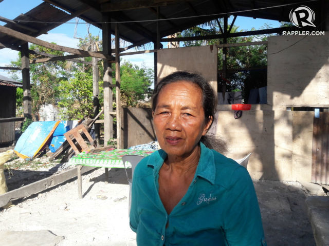
CabauatanUNFINISHED. Prescilla Jumao-as stands in front of her house, which was constructed after Super Typhoon Yolanda struck in 2013. The house remains unfinished.
UNFINISHED. Prescilla Jumao-as stands in front of her house, which was constructed after Super Typhoon Yolanda struck in 2013. The house remains unfinished.
CEBU, Philippines – Filipinos in northern Cebu will never forget who and what they lost to Super Typhoon Yolanda (Haiyan) on November 8, 2013.
Yolanda destroyed towns in the Eastern Visayas before plowing through northern Cebu.
Two and a half years later, most of the survivors of Yolanda are still suffering. Many of them say they have not fully recovered. (READ: Yolanda rehab: Only 30% complete as 2016 begins)
Last Monday, May 9, they trooped to the polls and voted for the first time since the typhoon struck.
What do the Yolanda survivors want from their leaders?
'We want homes'
"Kung maka-storya man gani nako ang sunod nga presidente... i-ampo gyud nako nga kami, mga biktima sa Yolanda, hatagan niya ug mga balay nga matawag gyud namo nga puy-anan," said a teary-eyed Prescilla Jumao-as.
(If I could talk to the president... I pray that he would give us, victims of Yolanda, houses we can really call home.)
Jumao-as, 65, said the government promised her a new home in 2013. Two and a half years later, she's still waiting.
What's worse, she added, is that her grandchildren had to suffer with her.
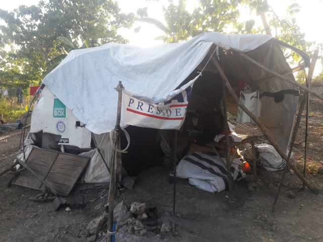
MAKESHIFT HOME. Tents housing Yolanda survivors haven't disappeared in Daanbantayan, Cebu. Photo by Richale Cabauatan/Rappler
Jumao-as was dropped from the list of survivors who needed housing and was never told why. She believes it's because she knows no one from the Department of Social Welfare and Development (DSWD). NGOs which promised to help also never returned.
Jumao-as said it seems that the government has forgotten about them. "And maybe God has, too?" she wondered.
She is now pinning her hopes on president-elect Rodrigo Duterte.
Free education
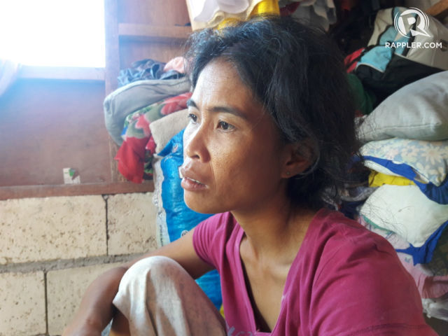
DREAMING. Catherine Bentulan dreams of free education for her children.
"Dili gyud siya sayon uy. Dili gyud," said Catherine Bentulan, a mother of 4.
(It's not easy. It really isn't.)
"Giampo gyud nako nga kung kinsa man gani ang musunod nga presidente, iyaha gyung himuon nga libre ang edukasyon para sa pareha namo nga dili pa gyud kaya ipadala sa eskwelahan ang among mga anak," Bentulan told Rappler.
(I pray that whoever the next president is, he makes education free for people like us who can't afford to send our kids to school.)
Bentulan's eldest child is in college; the second one, a 9th grader; and the third one, in elementary school. Her youngest is a toddler.
She was 4 months pregnant the day Yolanda destroyed their house, which had just been standing for a week and hadn't even been furnished yet. She had a miscarriage in the days following the typhoon.
Although Bentulan often wishes that her baby had lived, she said that what happened might have been for the best: "I'm glad he or she didn't live a day to experience our hardships."
Bentulan shared that even before Yolanda came, they struggled to send their kids to school.
She hopes to see the next president, even if he weren't the one she voted for, prioritize education for under-privileged families like hers.
Higher pension
PENSION. Lorita Alarde hopes president-elect Rodrigo Duterte will prioritize increasing pensions for senior citizens like her.
"I hope pensions will rise. Today, it's not enough to raise a family. I'm old, you see. I can't work anymore. They don't hire the elderly and I have grandchildren to feed," said Lorita Alarde, 85 years old.
When Alarde's husband, Fernando, died in 1985, she had to make do with the small pension he left her. She had no job. She was always tending to the house and to the children.
A P3,500-pension today is not enough to provide for her 6 grandchildren, she said.
Alarde hopes Duterte will listen to the elderly like her – and fast – because she believes she doesn't have much time left.
Programs for farmers, fishermen
CABINET. Ruben Jumao-as shares that the cabinet behind him is the only possession that he was able to save during Super Typhoon Yolanda.
"I hope he gives more attention to the farmers and the fishermen. Give them more jobs and privileges," said Ruben Jumao-as, who has worked as a caretaker of a hacienda for more than 20 years.
Yolanda damaged hectares of the sugarcane plantation he takes care of. Tall sugarcanes turned into twigs scattered on the ground after the typhoon came. The plantation has yet to fully recover.
Jumao-as said it's painful for him to see the farmers working under these conditions. "They always seem tired and unappreciated," he said.
Big businesses, he added, make it even worse for farmers and fishermen who make so much less even with all their efforts combined.
Jumao-as relayed his message to Duterte: "Mr President, please take care of our farmers and our fishermen." – Rappler.com
Richale Cabauatan is a Rappler intern and Mover.